Saturday, February 23, 2013

"Tree farm trekking" - hiking the logging roads on Pacific Northwest timberlands

One type of hiking in the Pacific Northwest of western Washington and western Oregon is what I call "tree farm trekking". Hiking and bushwhacking to elevation high points is called "dumpster diving". This type of hiking is on gated, gravel logging roads that pass through clearcuts, second growth forest and recently restocked young forests of seedlings (often Douglas-fir).  Most people avoid hiking in timberlands since logged-off landscapes look ugly, ruined, destroyed and devastated to most people. I used to avoid timberlands for hiking but grew to appreciate some of their aspects when hunting for ruffed and blue grouse.


This winter we've been hiking up gated logging roads on Washington state Dept of Natural resources and private timber company land.  Timberland open to public travel in the Pacific Northwest is often owned and managed by private timber companies and state government. In Oregon, state timberland is managed by the Oregon Department of Forestry. Private timber companies around here in northwest Washington are usually Sierra Pacific and Longview Timberlands. On weekdays, you have to keep an eye open for log trucks, heavy equipment and speeding trucks if there are crews working in the area.

This type of hiking is definitely not wilderness hiking; expectations must be reset and these forests places in context. These lands are officially designated for wood production and managed by professional foresters. State and private "working forests" are not supposed to be natural areas or wilderness preserves just like farms, pastures, subdivisions, cities and your backyard and garden are not. However, timberlands are much more natural and quiet than farms and rural areas and many "wildlands" in more developed parts of the US that many people perceive as pleasant, idyllic, aesthetically-pleasing landscapes worthy of appreciation and preservation. 
 
Tree farm trekking is a good option when snow at higher elevations in the mountains is bad due to ice, crust or high avalanche danger. Tree farm trekking is a also good option when tides are not right timing for saltwater sea kayaking or rivers too high for safe canoeing from recent heavy rains or snowmelt. Do NOT go tree farm trekking in summer when high elevation trails in scenic subalpine zones are snow-free.

Most people prefer trails in natural settings and would avoid hiking on logging roads passing through clearcuts. While I don't prefer timberland hikes I do admit there are positives.


  •  Dogs can run off leash and it's unlikely we'll see other people and disturb them.
  • There are almost no trails not buried by snow in winter and much of spring in the Northwest. A lot of outdoor recreation in the Pacific Northwest involves traveling on, and dealing with, some form of water be it river, lake, saltwater or snow. There are no options for snow-free, mountain, wilderness hiking from about mid-October until July in the Pacific Northwest. The mountain wilds of the Pacific Northwest are different than the mountain wilds of the central and southern Appalachians or the Southwest. Gated logging roads may be the only snow-free hiking option in some areas and it's much better than staying home. Many people hike the same low elevations trails over and over, year after year. Examples, would be the Chuckanuts and Angels Rest in the Columbia Gorge. Eventually, I'd rather explore new areas even if the route is a gated or seldom-driven forest road.
  • Logged-off landscapes are not devoid of plants and wildlife. There is Nature to be seen on tree farm treks. It is open space and somewhat natural Wildlife like black bears, deer, porcupines, grouse, elk, hawks, eagles, frogs, salamanders, many songbirds. Common forest wildflowers in spring. Land use regulations require riparian buffers along creeks. 
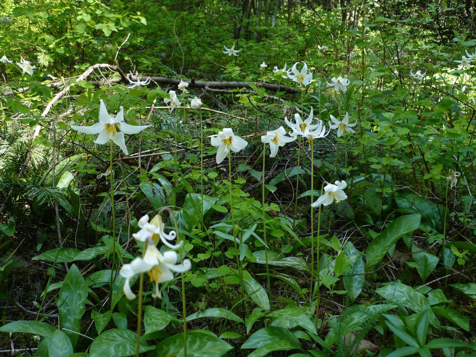
avalanche lillies in early May

Western trillium
 
Below is an excerpt from Trees Are the Answer by Patrick Moore.


  • A lot of people think logging road hikes are boring and not worth walking. In my experience, it's not worth pushing a mountain bike up to coast and speed back down. Sometimes I'll push the bike. It depends on the road. Some logging roads are pretty steep. Bikes are best for rolling terrain.


  • It's usually quiet, there's fresh air, and it's exercise. Logging roads can be steep and gain a lot of elevation so can be used as training hikes for real mountain hikes in summer. Motor vehicles like dirt bikes and 4-wheeler/quad/ATVs are not usually not allowed on most private timber company land. Sometimes OHV riders illegally ride around gates, down and over trenched berms and on old skid roads.  Gates are good because they block pickup trucks and Jeeps which in turn cuts down on unsafe target shooting, trash dumping and mudding.
    There are scenic vistas from clearcuts. Snowshoeing or cross country skiing on higher logging roads is best when unsightly slash and logging debris is covered by snow. 


    Logging was more intensive at around 3-4000 feet elevation in the 1970s and 1980s in the Cascades. I suppose they were logging silver fir and Western hemlock. These areas often hold snow well into June and can be good for cross country skiing. An example would be Slide Mountain south of Kendall, WA.
    snow at 4400' in early June North Cascades
    old rubber caulk ("cork") boot
    Below are some educational materials which will help understanding of what you may see when exploring timberlands  
    1.  History Channel's Ax Men shows why and how loggers do what they do.
    2. A much more critical book of logging in the Northwest is Wintergreen: Rambles in a Ravaged Land by Robert Michael Pyle 
    3. The Footsore series by Harvey Manning has suggestions of hikes and explorations in western Washington timberlands, farms, cities and rural areas. Harvey Manning accepts this type of hiking and recommends not being a "wilderness snob" (in Footsore 4). Footsore books were scouted in the late 1970s and early 1980s so some of the suggested areas have been posted No Trespassing and/or closed to the public by residential development. 
    4. Craig Romano's write up for Bald Hills is a good example of an article of tree farm trekking
    Camping and campfires  are not allowed on private timber company land. Camp on public Washington DNR or Oregon ODF land if you need a place to camp.

    Hiking up gated logging roads in the Pacific Northwest can be a lot more wild than hiking on trails and "wilderness" in other parts of the USA. And, it's better than not hiking, biking or exploring at all.

    Friday, December 14, 2012

    Cross country skiing around Mt Baker


                        CROSS COUNTRY SKIING IN WHATCOM COUNTY NEAR BELLINGHAM

    The North Cascades in Whatcom County and elsewhere in northwest Washington state 
    usually have lots of snow on the many mountains. This should make for some good ungroomed cross country ski touring for people who aren't extreme or skilled backcountry skiers.  But, that's not the case across much of the North Cascades. The Southern Washington and Oregon Cascade mountains are better for ski touring for most people on New Nordic Norm Backcountry (NNN-BC) gear, Salomon Nordic Norm Backcountry (SNS-BC) or 3-pin touring gear because the North Cascades are too steep and avalanche prone except for ski mountaineers or snowshoers, both which should have formal avalanche training and all the equipment.  

    On Turns-all-year.com, this type of ski touring is often called "low angle touring". There are extensive logging road systems on National Forest and state DNR lands on the westside North Cascades of course but most of those have been taken over by snowmobiles.  Around Mt Baker, the Canyon Creek and Glacier Creek areas are dominated by snowmobiles especially on weekends.  This is just a fact of life that the quiet and clean air seeking XC skier must work around. 
    The Sno-Park on Mt Baker Hwy at the North Fork Nooksack is at 2000 feet elevation which is low elevation. It sometimes does not have enough snow and can get crowded and overused. The trips below are alternatives to the Salmon Ridge Sno-Parks. Outside of Salmon Ridge there are no other non-motorized Sno-Parks around Mt Baker and the snowshoer and skier must find their own routes. 

    Since there is no Sno-Park on trips I have done below, the skier/snowshoer must drive as far as they feel comfortable to park then proceed on foot. A saw or ax is good to have to cut blowdowns off the road. The car should be good in snow preferably with 4 or all wheel drive. Tire chains and a shovel are a must. Be careful to not get stuck in a ditch when parking. Take a GPS waypoint at the car before starting off.

    Besides steep, avalanche-prone terrain, another challenge for XC skiers in northwest Washington is that a lot of the old logging roads from the heyday of clearcutting in the 1960s, 70s and 80s are now filling in with alder whips and washing out from landslides.  These old logging roads need to be brushed out if they are to stay cross country ski routes. If you don't know if an access road is open call the US Forest Service in Sedro-Woolley. Their webpage on road/trail access has information too but can sometimes be outdated.


    Every cross country skier in northwest Washington should have a copy of "Cross-Country Ski Tours: Washington's North Cascades" (2nd edition,1996) by Tom Kirkendall and Vicky Spring.  They should also have the US Forest Service road map of Mt Baker-Snoqualmie National Forest and the Green Trails maps for the Mt Baker area like Mt Baker (#13), Mt Shuksan (#14), Hamilton (#45) and Lake Shannon (#46). 

    I also highly recommend the Chuckanut Cross Country Skiing webpage at http://chuckanutcrosscountryskiing.wordpress.com/route-maps-weather-gear/routes-and-maps/

    Google Earth is an amazing tool for research destinations. Learn how to use it fully and you can can find out places to explore. These ski trips are easy to see on Green Trails maps. Mt Shuksan #14, Hamilton #45 and Lake Shannon # 46 and Mt Baker #13 have the ski tours closer to Mt Baker. These Green Trail maps are must-haves.

    Below is a list of areas that I have XC skied that not many people know about

    1. Twin Lakes Road up to Swamp Creek: FR 3065 and 3066.  This is the road up to Yellow Aster Butte trailhead. Park at the Sno Park then bushwhack through forest to the gravel pit.  Then ski west to the Twin Lakes Rd. About 3 miles up is the Swamp Creek spur. The bridge is out but can sometimes be skipped across. An old logging road continues up into an old clearcut for more views.
    2. upper Anderson Creek: FR 3071, from the Sno-Park.  Continue past where grooming ends and to the end of the road in a hanging basin.
    3. upper Kidney Creek Rd: FR 3130.  Springtime tour.  This old road off Canyon Creek Rd north of Church Mtn is getting brushy and there could be blowdowns down low.  The Canyon Creek Road is blocked due to landslide in 2012.
      spring corn snow on Kidney Creek Road
       
    4. Welcome Pass: hike to the snowline with skis.  Trail is very steep.  Ice ax was necessary.  Surprisingly easy skiing up on the ridge.  This is real backcountry skiing. Illegal snowmobile use on this ridge well within the Wilderness boundary. Most people would use snowshoes on this trip.
    5. Porter Creek Rd: gated first left off the Middle Fork Nooksack Rd (FR 38).  Requires a low snowline at about 500 - 1000 feet elevation. Ends at a high clearcut with good views of Twin Sisters Mountains. 
    6. Dailey Prairie from Middle Fork Nooksack: there's a new bridge over the Nooksack as of Oct. 2008. The mining company rebuilt the bridge in Aug. 2008. People park at the bridge and walk over. Weekdays may see mining trucks. Bowman Mountain seems like a good destination too but I did not make it all the way on foot.
    7. Stewart Mtn from Middle Fork Nooksack: drove up as far as you can on FR 38 then skied up the first left beyond the turnoff that goes to the new, possibly closed bridge over the Middle Fork Nooksack.  Views of the Twin Sisters and other mountains are very good.  The photo above is from this trip.  This tour depends on correlating snowline.   There's a long spur road running east below that top that should be explored.
      route up Stewart Peak from Middle Fork Nooksack
    8. DOT comm tower from Wells Creek Rd: FR 33.  Starts at gate above Nooksack Falls.  This trip requires a low snowline. 
      North Fork Nooksack from near Nooksack Falls
    9. upper Cougar Divide Rd along Wells Creek: FR 33.  This road is gated above Nooksack Falls until some time in spring.  Ride mountain bike to snowline in spring then start skiing.  Avalanche slopes on west side of Barometer Mtn make this a tour for spring when it's stable. 
       
      mountain biking to the snowline on Wells Creek Road
    10. Slide Mountain: on DNR land south of Kendall.  Drive to snowline from North Fork Rd beyond the turnoff to Racehorse Falls.  Turn right uphill before the gravel pit.  I was able to drive to a large, new clearcut at maybe 1500 feet elevation (?!) in spring.  This is a spring tour.  There's a great little bowl beyond the lake where the road deteriorates.  There's a lake at (UTM, NAD27 CONUS) zone 10U 0570571, 5415015, elevation 4212 feet.  A highpoint goal on a spring snow posthole hike was Pk 4884 on Slide Mountain at UTM Zone 10U 0572191, 5413132. 
    11. Toboggan Pass from Racehorse Creek: This was hard to find at first. I drove beyond the turnoff to Racehorse Falls and went right up toward Racehorse Creek. I parked at junction of road that runs down to bridge over Racehorse Creek and started skiing. Had lunch below the communication tower. The ski down was outstanding due to perfect slope and perfect snow. Google Earth shot here.
    12. Canyon Lake Community Forest: I drove to the snowline.  Hike or ski to snowline then ski to viewpoint as described in Ken Wilcox book "Hiking Whatcom County".  The open areas with "reprod" in old clearcuts up on the ridge, south of the lake look pretty good.  The access road is closed from Mosquito Lake Road due to washout. However, may be possible to access Canyon Creek Lake from # 11. Toboggan Pass above in spring when you can drive higher due to a high snowline
    13. Upper Glacier Creek: FR 39 and 36.  These are the roads near Heliotrope Ridge trailhead.  Be sure to go on a weekday in spring or there will be tons of snowmobiles.  Magnificent views from Lookout Mtn and there's a nice bowl on the north side for yo yo-ing.  The east side of Pk 5328 has nice views.  
    14. West Church Mountain: FR 3120.  This road is gated and closed to motorized use until April 15 to protect wildlife habitat so it's a good place to explore before then to get away from noise and stink. It was accessed from the Canyon Creek Road which unfortunately closed due to washout at SR 542 near Glacier.


    Places I want to XC ski but have not and hope to hit this winter/spring of 2012 - 2013

    --The Finney Tract of the Mt Baker-Snoqualmie National Forest south of Lyman, west of Darrington and east of Mt Vernon. I wish this area had a non-motorized Sno Park.  The terrain is more mild than other parts of the North Cascades, there are a lot of old logging roads and it's closer to where a lot of people live.  Now there are only snowmobile Sno-Parks.  This means you should only ski here on weekdays in spring.  I haven't skied here but want to especially the road to Gee Point trailhead and Finney Peak. Trip reports on NWhikers here and here.
    --The climbing route to North Twin Sister Mountain from the Middle Fork Nooksack has a lot of logging roads.  It goes though Dailey Prairie (see above).  The upper part just west of the Mt Baker Wilderness boundary and west slope of Twin Sister Range has logging roads and high elevation clearcuts end which look like good places for low angle ski touring. They say a mountain bike is good for the ridge back down to the bridge over the Middle Fork Nooksack

    -- the first big open subalpine bowl on Goat Mountain Trail off the Hannegan Road in spring.  Good skiers ski down from near the top.  I can't.  I'd be happy with yo yo-ing in the bowl after carrying in skis on a hike in spring.  

    --I've hiked to Hannegan Pass in spring.  If the avalanche hazard is low, the terrain on the west side of the pass looks like it has some easy XC, backcountry ski touring.  This would be good area for a spring, corn snow camping trip.

    --Lookout Mountain south of Bellingham looks like it may be a good XC ski tour if the snowline was low.  That'd be unusual.  This is a hike in Ken Wilcox's "Hiking Whatcom County"

    --the powerline corridor that steeply climbs Stewart Mtn from the North Shore Lake Whatcom Trail looks like it'd be a good ski tour if the snowline was low and there was plenty of snow at 2000 feet at this location.  That'd be unusual.  This is a hike in Ken Wilcox's "Hiking Whatcom County"

    -- Rankin Creek Road at the end of the Middle Fork Nooksack road FR 38. This is near the Ridley Creek trailhead (seldom used). This part of the Middle Fork road is gated in winter at Wallace Creek. It climbs on switchbacks from about 2500 feet elevation to 3600 elevation. (Gren Trails # 45 Hamilton, WA)

    --  FR 1130 the road to Rainbow Ridge trailhead. Ascends to 3600 feet elevation with good views from openings and second growth forest in old clearcuts.

    -- Mt Josephine which is the red rock-topped peak north of Hamilton, WA. We've hiked it from logging roads that approached from the west. I've also hiked to upper Josephine Lake from the south east. The ridge road seems like a good ski tour. 


    Sunday, December 4, 2011

    hiking and camping summer 2011


    Perry Creek meadows 8/6/11
    Summer of 2011 was not that great for hiking in the Cascades because snowpack melted off atleast 6 weeks later than average due to cool, wet weather that persisted into July. Not much snow melted this spring. I only went backpacking once.  In early July I hiked to Lake Ann on about 4 feet of snow ice ax in hand most of the way. Around 4th of July, I skied out to Artist Point from Mt Baker Ski Area. That was the latest in the year I've ever skied. Snow was bumpy corn.

    So, we did a lot of car camping with dayhikes up high on to the snowline. We did more hikes off the Mountain Loop "Highway" and around Darrington this summer. We did not drive over to the Methow country to hike in or near the Pasayten like we normally do. Weather finally turned hot and summery in late August and much of September. Wildflowers that normally bloom in late July and early August during a normal year bloomed in late August and September. Flies were bad and persisted well into September. There was so much snow above 4000 feet elevation this year, I filled a cooler with snow from a small patch of snow on the side of a high elevation, old logging road! High elevation hikes like Ptarmigan Ridge on Mt Baker probably didn't even melt out at all.


    Since we car camped this year on weekends and on a week off in October, we have our car camping technique worked out. The iron tripod and big pot is great for boiling a lot of water for dishes and washing up. We bought a folding table with a built-in sink, hanging wall and table for camping where there's no picnic table. It's great to use as a portable kitchen. In early October, I bought a Great Northern Camp Stove (wood). We used in under a rainfly with the chimney on the side of the rain fly which seemed safe. I have also used it under the awning of a canvas Baker tent. It needs a hand bellows. Wood must be small and dry.  I could only keep the fuel burning and heat coming with the door open. It requires trial & error and practice to use correctly. I still have yet to use it with the Baker tent in the middle-front. It should work best at that location since heat should get entrapped in the tent.


    We saw way too much irresponsible pooping this summer. The lazy, thoughtless pooping in the woods is getting bad. Every place we camped this summer we saw unburied human feces and stained toilet paper on tent pads, behind trees next to campsites and on rocky beaches next to running water. On Segelsen Ridge near Darrington, we turned down an old logging road spur and a guy popped up from squatting on the side of the road and waved us off. This idiot was taking a dump on the side of the road. Someone doing that probably isn't burying it.

    Our Australian shepherd died in mid July of old age/cancer. He was 11.  We originally planned on holding off backpacking until late August and September because of lingering snowpack. But, we got a Llewellen setter puppy in late August so had to stick with car camping and day hiking. At about 12-14 weeks the puppy could only hike a few miles. At about 4 months he could hike most of the day. At 5 months he can hike like an adult dog and I've even taken him chukar hunting.

    September we hunted grouse in mornings and evenings and hiked during the day. It's been the poorest year for grouse since I started hunting them in 1999. More on that later. I have a rule that I only camp when there's 10 hours of daylight. At the latitude of Washington state, that means no camping from about Halloween until about February 12th. I may bend my 10 hour rule is the wood stove and canvas tent take a bite out of the long winter night. I'm looking forward to camping again in February.

    Wednesday, June 1, 2011

    canoeing the Skagit from Copper Creek to Rockport

    Ski touring slushy spring snow under overcast skies and intermittent rain showers sucks.  Normally, I look forward to ski touring on spring snow.  But this spring was been wetter and cooler than average.  It seems every weekend day that is open for skiing the weather forecast is for rain showers with snowlines above 5000 feet elevation.  So, we've been doing more canoe trips.  Most of the canoe trips I want to do in northwest Washington are Vern Huser's write-ups in "Paddling Washington".  Lowland and foothill canoe trips are good for a weather pattern with dry weather down low and clouds and rain in the mountains.


    Skagit River near Sutter Creek, Washington
    The weather forecast last Memorial Day weekend was for clouds and rain on Saturday with mostly sunny on Sunday and Monday.  So, I chose to canoe the Skagit River from near Copper Creek to Howard Miller Park in Rockport.  The guidebook says it's 16 river miles and 3-4 hours long.

    Sunday was sunny in the lowlands near the coast but mostly cloudy in the foothills and North Cascades.  Dark, gray cloudy skies stuck around all day east of Sedro-Woolley.  Huser's description of the put-in on the Ross Lake National Recreation Area needs some improvement.  To reach the put-in you drive 0.7 miles east of Bacon Creek bridge, turn right/south on a dirt road signed "NPS Road 213" and drive for 0.2 miles to the end. 

    The paddle to Marblemount only took about an hour and is the easiest stretch of the trip.  I remember 3 areas of frothy water with waves that got a little dicey.  All are downstream from Marblemount.  There were a few areas with sweepers but all were easily avoided.  1 or 2 sharp bends in the river had eddies that complicated avoiding fast water on the outer bank.  Currents come at the canoe from unexpected directions.


    There was only 1 other boat on the water with us, a small motorboat.  A GPS unit would've been nice to have so I could've known how fast were were going. We were going faster than it feels in the boat because flowing water changes your perception of speed.  We saw mergansers and a bald eagle.

    The paddling portion of the trip took 2 hours and 45 minutes not including lunchtime.  The bike ride back to pick up the car was 15.4 miles and took me 1 hour and 15 minutes.  The road shoulder on SR 20 is narrow in spots in between Rockport and Marblemount.  There's a wide road shoulder on SR 20 east of Marblemount. 

    Monday, May 30, 2011

    trip to Virginia and West Virginia

    Allegheny Mountain from old pasture on the High Meadows trail
    Early and mid-May we were in Maryland, Virginia and West Virginia visiting family and friends and squeezing in some hiking and camping.  Mostly we hiked parts of the Allegheny Trail in West Virginia and on the Northern Neck of eastern Virginia.  The trip report with pictures and a video is here and here on NWhikers.net.  I made this 4+ minute video of the trip which is up on YouTube

    Below are some conclusions from the trip and what I learned.

    It rains a lot in western Washington and western Oregon.  Especially this late winter and spring.  But, Pacific Northwest rain is showers with many overcast days from November to May.  In the eastern US, rain is sometimes very heavy and it's humid.  If I still lived or spent more time in the east I'd use a synthetic fill sleeping bag.  The humidity seems to shrunk my down bag's loft.

    Greenbrier River rail-trail, West Virginia
    We rented mountain bikes for 2 hours from the store/restaurant/hotel in Cass, West Virginia and went for a ride south on the Greenbrier River rail-trail.  They were cheap and not properly maintained.  The bikes would've been fine with a tune-up.   It was about a 5 hour window of tolerable weather with just a short sprinkle. There's also a rail-trail from Glady to Durbin that would be a good bike ride.  Athough, my favorite activity is hiking on rugged trails in natural areas, a mountain bike is sometimes the best way to go.  There are a lot of interesting places to explore in West Virginia that are rural with scattered forests but do not have trails.  There are a lot of country roads, flat and rolling "double track" national forest gravel roads to explore.  I can't ride a bike for more than a few hours because my ass gets sore and my toes go numb.  So, I ride slowly, soak up the scenery, take lots of breaks and get off the bike to shake off and look at the surroundings more closely.  

    The Greenbrier River was raging due to recent heavy rain.  It would've been fun to take a canoe down the river.  Since we took an airplane back east, we did not have our own canoe.  We could've rented a canoe paid for a pick-up but that's frustrating when you own your own.  The same can be said for bikes and cold-weather camping gear that is too big to take on an airplane. 

    Flies and gnats were worse than I remember from previous trips back east.  They kamakazied into eyes and ears.  A bandanna was necessary to whip them away.  In western mountains, mosquitoes and flies are worst the first few weeks after snowmelt when it's cooler in the mornings and evenings.  In the east, flies and gnats seemed to come out during the warmest part of the day usually in the afternoon.  

    short Potomac River beach in George Washington's Birthplace
    There are interesting places to explore in Tidewater Virginia.  We stayed in Colonial Beach and saw some of the Northern Neck.  Much of this area is rural with forests and beaches and coves in the Potomac and Rappahannock rivers.  Although there is a little bit of hiking, you really need a canoe and bikes to explore this part of Virginia.  It would've been great to have the sail rig on the canoe for the Potomac River at Colonial Beach, Popes Creek and Westmoreland State Park.  Too bad it's practically impossible to get the sail rig and canoe on an airplane and rentals can be non-existent or too expensive.

    Speer PeaPod with 8x10 silnylon tarp on hammock
    I'm still on the fence about hammock camping.  I slept in a hammock with a Speer PeaPod a few nights.  The eastern US is better for hammocks than the Northwest since trees are smaller and closer together and in the Appalachians, the ground is often rocky.  Since the air is more humid and elevations are lower in the eastern US, nighttime temperatures usually don't fall as much as the western mountains and high deserts.  Site selection can still be a challenge with a hammock.  Trees have to be a right distance apart and a right range of diameters.  Ground brush can't be in the way where the hammock is placed.  Sometimes suitable trees are not in or near designated campsites.  Hammocks are best for areas where campsites are not limited to official designated tentpads.  Free-standing tents or tarps can be more convenient than hammocks in places with designated campsites like national parks and developed car campgrounds.  As for comfort, hammocks feel weird at first.  It's kind of like sleeping in a recliner or couch.  Hammocks are much better for rain than tents or tarps.  A hammock under a tarp gets much less condensation than a tent. 

    The Speer PeaPod is warm and cozy but it is bulky in the pack compared to a good sleeping bag.  The PeaPod covers parts of the hammock that you don't come into contact with so some of its bulk and weight is wasted.  I'll have to look into an underquilt.

    Sometimes camping in a hammock is not possible.  One night I camped at a developed car campground near Seneca Rocks.  It was walk-in camping with tent pads in a field so the hammock could not be used.  I set the Speer Winter Tarp up with 2 sticks as poles. It kept me dry from the rain shadow.  I pitched it low for privacy and rain protection.  The ends were partially open but a free-standing tent would've been best for an open developed campground with innocent bystanders nearby.  But, you can only carry so much camping gear with you on an airplane.  The duffel bag of camping gear cost me $45 round trip to check with the airline.  The tentpad had anthills but the ants stayed below ground and did not explore me in the sleeping bag.  Humidity and condensation wetted the shell of my thin, ultralight down sleeping bag even though I took every measure to keep it dry. 

    I like and miss the central Appalachians of western Virginia and West Virginia.  Compared to the Cascades they are better for the recreationist in some aspects.  The snow-free hiking season is much longer.  There are no avalanches to worry about.  No snowfields to cross, slide down and die to get injured.  Road washouts are rare and get fixed sooner.  Trails are easier to follow even if they haven't been maintained in awhile.  Bridges don't get washed out as much.  This relative lack of obstacles and ease of access makes trips easier and less stressful.  

    However, the Cascades are better than the Appalachians in many respects.  First of all, the Cascades and other western mountains are much wilder, more vast and have more grand scenery.  The Pacific Northwest has more trout fishing, more mushrooms and bigger huckleberries.  The Northwest has more diversity.  Within a few hours of Bellingham is sagebrush steppe, eastside pine forests, glaciers and craggy high alpine mountains, lowland conifer forests and islands and coasts which the eastern US does not have.  Each biome in such a small area has a different look and feel to it.  Although the mid-Atlantic has the Chesapeake Bay system and the Appalachians, it all has that green, humid feel to it.  It's a nice place to visit but I wouldn't want to live there.  And that's not even considering the traffic and suburban sprawl.


    Sunday, April 24, 2011

    snow, weather, water conditions dictate what to do and where to go

    Conditions for choosing between lowland forest hiking, canoeing or snowshoeing and cross country skiing have been challenging for the last few weeks.  Overall, weather in northwest Washington has been cool and wet this spring.  In reality, it's not quite spring but not still winter either.  The sun's rays are too strong to be winter and days too long.  As the Northwest Avalanche Center jokingly put it,

     "...Snowpack Analysis
    INSTALLING SPRING...

    ███████████████░░░░░░░░░░░░░░░░░ 44% DONE.

    Installation delayed....please wait.

    Installation failed. Please try again. 404 error: Season not found.
    Season "Spring" cannot be located. The season you are looking for might
    have been removed, had its name changed, or is temporarily unavailable.
    Please try again.

    ++++++++++++++++++++++++++++++++++++++++++++++++++++++++++
    Continued cool to cold temperatures with periodic showers has been the weather pattern over the past four days, well a lot longer actually, but we'll focus on this week for now. Last weekend a frontal passage was accompanied by moderate warming and precipitation that caused a fairly extensive avalanche cycle of new storm snow slab avalanches and many wet loose slides..."

    Weather guru Cliff Mass's blog entry for 4/15/2011 says

    "2011 is clearly the worst year on record with the fewest number of days above 55F!!!...You would have to go back to the 1950s to find the runner up..."

    Last weekend, I went up to Racehorse Mountain near Deming to try out a new pair of snowshoes.  Normally, I hate snowshoeing but they're good for crappy snow and on steep, timbered slopes that are un-skiable.  Snow blocked the road at 2300 feet elevation which is unusual for mid-April.  However, all the snow was relatively new not more that a month old in my estimation.  You could probably drive higher last winter when the snowline was higher.  The winter weather was almost-mild until late February or early March and it's been wet and cool ever since.  This is not good for access to the higher mountains.  

    When it's topping out at 35 degrees F at Heather Meadows on Mt Baker with a few inches of snow almost daily, that means wet, heavy sticky snow in the afternoon that is difficult to ski and increased avalanche hazard.  Snowlines have been dropping down too.  This is kind of a good thing because it means snow at higher elevations will be lighter and fluffier so better for skiing.  However, that also means low elevation snow (defined as 2-3000 feet) blocks gravel roads that access touring areas.    So, we have not been doing much backcountry skiing or snowshoeing even though there is a lot of snow.

    Every year, like most people, I look forward to spring .  In the Cascade mountains, there can be excellent spring ski touring once several freeze-thaw cycles occur and "corn snow" forms.  Turns-all-year.com says, 

         "Here in the Pacific Northwest, we are blessed with deep winter snows and long cool springs which help preserve the mountain snowpack, making possible year-round skiing. Summer skiing in the Cascades can provide some of the nicest backcountry conditions of the year: a fast, consolidated, and consistent snowpack; warm, sunny weather; and long hours of daylight...".   

    Snowpack stabilizes in spring so avalanche hazard drops.  But, this year the North Cascades are currently stuck in between winter and spring.

    There's not much freezing and thawing of the snowpack so almost no corn snow so far this April of 2011. Yesterday's forecast says it'll alternate between regular winter snow at night with wet, sticky snow mixed in with rain during the day.
     

    There's a huge snowpack at Mt Baker since it's been snowing almost every day up there.  The snowpack is about 150% of the 30 year average! That's an incredible number when you consider than even an average/100% snowpack is very deep and doesn't melt off until late July.  High elevation trails like Ptarmigan Ridge may not melt off and be hikable for average folk until mid-August.  Whether we get warm, sunny weather this spring and early summer will cause how fast snow melts.

    So...for the last few weeks we've been doing low-elevation forest hikes and canoe trips in the partial rain shadow around Anacortes and Bellingham during narrow windows of nice weather.  The edge of the Olympic Mountains rain shadow clips the lowlands around Bellingham.  But you don't have to go very far from Bellingham to reach soggy rainforest.  I consider the forests along the North Fork Nooksack east of Glacier as temperate rainforest. 

     
    Canoeing and kayaking is an option when snow and/or weather conditions in the Cascades are not good.  Besides river rating difficulty (Class 1, etc.) the big issues with canoeing Pacific Northwest rivers are:

    1.) tides

    2.) river flow and volume.


    When canoeing a river, you must check the river flow as measured in cubic feet per second (cfs).  The US Geological Survey has a webpage with past, current and forecasted river flows


    Canoeing bodies of water influenced by the tides can be fun.  You can ride the tide out then ride the tide back in.  Tides don't always coincide with when you'll be on the water.  The National Oceanic Atmospheric Administration has a webpage that forecasts tides.  Below is the tide table for the station closest to the Skagit Delta.  Paddling the Skagit Delta from the wildlife area headquarters requires a put-in and take-out around high tide.  Since the tide is going out quickly starting around 9am and lowest at 5pm, paddling this area from 11am to 4pm is not a good idea so a day-hike would be a better choice.

    Monday, April 4, 2011

    short spring vacation in Arizona March 2011

    Toward the end of every gray, cloudy, rainy western Washington winter, we're going crazy and depressed after months of dreary weather.  The one upside of all the rain is a lot of snow in the Cascade mountains which is good for skiing.  But, we get sick of snow by March and just need to get outside for awhile to enjoy warm weather in shorts and T-shirts.  For the last 10 years or so, I've gone down to the Southwest to hike and camp in the desert and to soak up sun during March or April.  A few weeks ago we flew into Las Vegas, got a rental car and drove east to Arizona which is our usual practice.

    Rincon Mountains of Saguaro National Park

    The first night we camped at the Bureau of Land Management's (BLM) Burro Creek BLM campground north of Wickenburg, AZ.  A lot of "snowbirds" were camped here long-term in their large RVs.  Retired people are pretty quiet campers.  We were the rowdiest campers there.  We tried hiking up Burro Creek canyon but the creek was too high from recent rains.  The camp host said kayakers from Phoenix ran Burro Creek toward Signal a few days earlier.  I wish I would've had the Sevylor Trail Boat for fording Burro Creek.  That would be fun and I haven't used it yet.  (I wish I would've had the Sevylor Trail Boat in 2009 when I had to swim across a deep pool on the Bill Williams River just down from Alamo Dam).  So we wandered around downstream from the campground then up a desert ridge for a few hours.

    Next day, it was cloudy and windy with a few showers in the area so we pushed on to Tucson chasing the sun.  Driving through Phoenix was unpleasant because of the disjointed beltway system.  It was very windy in Tucson but partly sunny.

    We began our exploration of Tucson area deserts with an introductory trip to the Arizona-Sonora Desert Museum.  It's a great museum with natural history displays and many live animals like red wolves, javelinas, cougars and much more.  Later in the day we dayhiked the west unit of Saguaro National Park for a few hours.  That night we camped in Tucson Mountain Park's Gilbert Ray Campground.  

    Next day we drove back across Tucson to the east unit of Saguaro National Park.  We got a backcountry permit for a 2-night, 33+ mile backpacking trip at the visitor center.  A family of javelinas lives near the visitor center.  We lucked out when they came right up to the window and starting taking dust baths with their babies in their depressions.

                (about 2 miles east of Grass Shack in the juniper/chaparral zone)

    I don't have the time to write up a full trip report but I will offer comments and advice from our experiences.

    When I chose backcountry campsites at the visitor center, I underestimated the difficulty of huge elevation gains of hiking from basin at Tucson's edge (about 1000 feet elevation) all the way up to 8000 feet at Manning Camp.  That's of course a 7000 foot gain but I figured since it was strung out over so many miles it wouldn't be so bad.   Thank God there were snow patches above 7000 feet.  I smeared snow onto my face, neck and wrists to cool off.  Despite the snow, low humidity was harder on skin and breathing than what I remember from past trips to Arizona.  It was a damn tough hike up to Manning Camp.  I suppose I've grown more accustomed to humid air? Melting snow also provided water.  I recommend staying the first night at Juniper Spring, 2nd at Grass Shack and 3rd at Juniper Spring.  That would leave time for side trips at the Manning Camp area in the high ponderosa pine forests.

    Water is heavy.  I carried about 3 quarts since I did not trust water availability at Grass Shack and elsewhere on the trail.  There was much more than expected due to recent snow at high elevations.  It would've been nice to ditch the tent and use a tarp since it was dry weather.  However, it was cold at night.  It dropped down to freezing at Juniper Spring and to about 40 at Grass Shack.  Manning Camp drops down to 22-25 at night this time of the year.  The tent keeps out scorpions, ants and insects and is warmer than a tarp.  Had I known, I would've brought a warmer sleeping bag, a tarp and carried less water.  "Oh well.  Live and learn".

    Unlike other March trips to Arizona, there were almost no desert wildflowers.  Locals say winter had a few dry spells followed by recent cold spells.  

    My Big Agnes air mattress did not get punctured by a cactus thorn.  My wife's Thermarest developed a leak so she as forced to sleep on 2 cheap, crappy foam pads (1 of which I packed) from Big 5.  Most desert ground is almost as hard as pavement so foam pads aren't comfortable.  A hammock is great in the desert if you can find a place to hang it.  There were trees to hang a hammock at Juniper Basin, Manning Camp and Grass Shack backcountry camps unbeknown to me when packing for this trip. With so much variety in elevation/temperature and ground, comfortable bedding is a challenge. 

    I thought I'd like to thru-hike the Arizona Trail.  After this trip, no way.  There's just not enough water and there's too much elevation gain from basin to range. It's not like the Pacific Crest Trail which maintains a mild grade and a lot of water.  Water shortages could foil an AZT thru-hike.  Section hiking the AZT seems doable, more practical and hence, would be more fun.

    One problem in exploring Arizona's wild lands is that most hiking areas require a high clearance vehicle to access.  4WD may not be necessary but you do need a vehicle like a small truck or jeep with high clearance.  Most of the roads down there on BLM land were built for mining and ranching not uninsured, Las Vegas airport economy rental cars.  Many roads cross arroyos and washes that flash flood during the summer monsoon thunderstorm season.  Storms wash rocks across many roads and cause erosion. 

    Photos of the trip are at Photos at http://www.flickr.com/photos/74014145@N00/sets/72157626128355503/ .